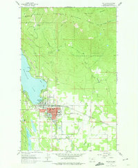
1962 Map of Whitefish
USGS Topo · Published 1974About this map
The Whitefish Range rises sharply above the town of Whitefish in this 1962 record, documenting a community balanced between traditional industry and its growing identity as a mountain destination. To the north, the Big Mountain Ski Resort and its accompanying Ski Lift mark the development of Big Mountain, while the Knights of Columbus Shrine and Whitefish Lookout Tower stand atop the high peaks. The town itself is shown in significant detail, including local landmarks like the Whitefish Hosp, National Guard Armory, and the Whitefish Lake Golf Club.
Find a feature on this map
49 named features on this map. Tap any name to fly to it.
Don’t see what you’re looking for? This feature index may not catch every label — zoom into the map to look around manually.
Map Details
Editions of this 1962 Whitefish Map
3 editions found
Other maps of this area

1906 · Kintla Lakes
USGS Topo · 1:125,000

1938 · Kintla Lakes
USGS Topo · 1:125,000

1943 · Kalispell
USGS Topo · 1:125,000

1957 · Kalispell
USGS Topo · 1:250,000

1960 · Kalispell
USGS Topo · 1:250,000

1961 · Kalispell
USGS Topo · 1:250,000

1962 · Columbia Falls South
USGS Topo · 1:24,000

1962 · Rose Crossing
USGS Topo · 1:24,000

1962 · Beaver Lake
USGS Topo · 1:24,000

1962 · Rhodes
USGS Topo · 1:24,000