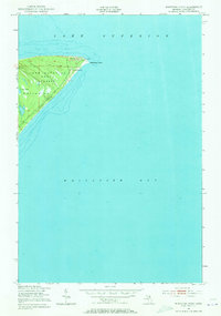
1951 Map of Whitefish Point
USGS Topo · Published 1973About this map
Whitefish Point serves as the focal point of this coastal survey, where the waters of Lake Superior meet Whitefish Bay. This shoreline landscape is dominated by the Lake Superior State Forest, a geography shaped by the maritime necessities of the mid-twentieth century. Near the tip of the point, the USCG Radio Sta and Fog Warning Sta and various Towers reflect the area's critical role in Great Lakes navigation. A small Cem and Little Lake sit tucked within the forested interior, while Whitefish Road provides the primary overland connection to this northern reach of the Upper Peninsula. The map preserves a quiet, functional era of maritime safety before later developments changed the character of this iconic Michigan landmark.
Find a feature on this map
11 named features on this map. Tap any name to fly to it.
Don’t see what you’re looking for? This feature index may not catch every label — zoom into the map to look around manually.
Map Details
Editions of this 1951 Whitefish Point Map
2 editions found
Other maps of this area

1951 · Vermilion SE
USGS Topo · 1:24,000

1951 · Shelldrake
USGS Topo · 1:24,000

1951 · Whitefish Point
USGS Topo · 1:24,000

1951 · Shelldrake
USGS Topo · 1:62,500

1954 · Sault Sainte Marie
USGS Topo · 1:250,000

1956 · Sault Sainte Marie
USGS Topo · 1:250,000

1957 · Sault Sainte Marie
USGS Topo · 1:250,000

1958 · Sault Sainte Marie
USGS Topo · 1:250,000
1985 · Two Hearted River
USGS Topo · 1:100,000
1985 · Sault Ste. Marie North
USGS Topo · 1:100,000