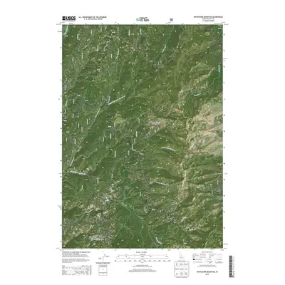
2013 Map of Whitehawk Mountain
USGS Topo · Published 2013About this map
Boise National Forest encompasses this high-elevation terrain in Valley County, centered on the prominent Whitehawk Mtn and the adjacent Whitehawk Basin. The landscape is defined by an intricate network of drainages, including the Deadwood River along the western edge and various branches of Warm Springs Cr that carve through the mountain slopes. The map detail reflects the management of the 2010s era, showing an extensive system of forest development roads such as Nat For Dev Rd 510 and Nat For Dev Rd 591, which provide access to remote areas like Bearskin Cr and S Fork Deer Cr. This 2013 survey serves as a precise record of the watershed and infrastructure within this protected backcountry region, capturing the hydrology of named features like Granite Cr and No Man Cr.
Find a feature on this map
54 named features on this map. Tap any name to fly to it.
Don’t see what you’re looking for? This feature index may not catch every label — zoom into the map to look around manually.
Map Details
Editions of this 2013 Whitehawk Mountain Map
This is the sole edition of this map. No revisions or reprints were ever made.
Other maps of this area

1891 · Bear Valley
USGS Topo · 1:125,000

1893 · Bear Valley
USGS Topo · 1:125,000

1909 · Garden Valley
USGS Topo · 1:125,000

1953 · Deadwood Reservoir
USGS Topo · 1:62,500

1957 · Challis
USGS Topo · 1:250,000

1960 · Challis
USGS Topo · 1:250,000

1963 · Challis
USGS Topo · 1:250,000

1972 · Cache Creek
USGS Topo · 1:24,000
1972 · Miller Mtn East
USGS Topo · 1:24,000

1972 · Scott Creek
USGS Topo · 1:24,000