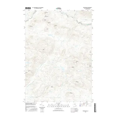
2016 Map of Whitehouse
USGS Topo · Published 2016About this map
The Whitehouse settlement area serves as a primary point of human activity within this 2016 survey of the Adirondack wilderness. Situated along the West Branch Sacandaga River, the landscape is defined by a dense network of water bodies and high peaks. Notable elevations such as Blue Ridge Mtn, Sugarloaf Mtn, and Grindstone Mtn surround a complex hydrology that includes Silver Lake, Meco Lake, and Mud Lake. The presence of Cole Rooney Flow and Motts Flow suggests the historical and natural manipulation of water levels in this forested terrain. While W River Rd provides limited access from the north, much of the area remains dominated by natural features like Ninemile Cr and the N Br W Br Sacandaga River, reflecting a region largely preserved in its wild state.
Find a feature on this map
40 named features on this map. Tap any name to fly to it.
Don’t see what you’re looking for? This feature index may not catch every label — zoom into the map to look around manually.
Map Details
Editions of this 2016 Whitehouse Map
This is the sole edition of this map. No revisions or reprints were ever made.
Other maps of this area

1901 · Lassellsville
USGS Topo · 1:62,500

1903 · Gloversville
USGS Topo · 1:62,500

1903 · Lassellsville
USGS Topo · 1:62,500

1904 · Piseco Lake
USGS Topo · 1:62,500

1906 · Piseco Lake
USGS Topo · 1:62,500

1907 · Lake Pleasant
USGS Topo · 1:62,500

1908 · Piseco Lake
USGS Topo · 1:62,500

1943 · Gloversville
USGS Topo · 1:62,500

1945 · Caroga Lake
USGS Topo · 1:24,000
1945 · Canada Lake
USGS Topo · 1:24,000