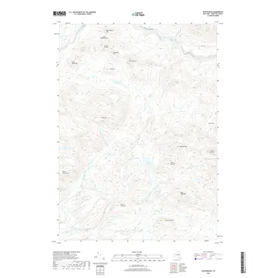
2019 Map of Whitehouse
USGS Topo · Published 2019About this map
Whitehouse sits at the end of W River Rd in this 2019 depiction of Hamilton County, serving as a gateway to the high peaks and deep waters of the southern Adirondacks. The landscape is defined by the winding course of the West Branch Sacandaga River, which is fed by numerous tributaries including Dugway Cr, Moose Cr, and Ninemile Cr. This modern survey reveals a region dominated by high elevations and interior lakes, where peaks like Sugarloaf Mtn and Blue Ridge Mtn rise above isolated water bodies such as Silver Lake and White Lake.
Find a feature on this map
40 named features on this map. Tap any name to fly to it.
Don’t see what you’re looking for? This feature index may not catch every label — zoom into the map to look around manually.
Map Details
Editions of this 2019 Whitehouse Map
This is the sole edition of this map. No revisions or reprints were ever made.
Other maps of this area

1901 · Lassellsville
USGS Topo · 1:62,500

1903 · Gloversville
USGS Topo · 1:62,500

1903 · Lassellsville
USGS Topo · 1:62,500

1904 · Piseco Lake
USGS Topo · 1:62,500

1906 · Piseco Lake
USGS Topo · 1:62,500

1907 · Lake Pleasant
USGS Topo · 1:62,500

1908 · Piseco Lake
USGS Topo · 1:62,500

1943 · Gloversville
USGS Topo · 1:62,500

1945 · Caroga Lake
USGS Topo · 1:24,000
1945 · Canada Lake
USGS Topo · 1:24,000