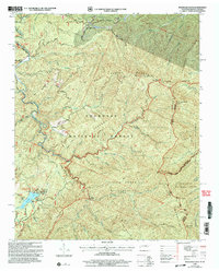
2003 Map of Whiteoak Flats
USGS Topo · Published 2004About this map
Cherokee National Forest and the Nantahala National Forest meet along the ridge of the Unicoi Mountains, which forms the border between Monroe County, Tennessee, and Graham County, North Carolina. This landscape is defined by its deep drainages and high gaps, such as Farr Gap and Harrison Gap, which have historically dictated the routes through these highlands. To the west, the Indian Boundary Recreation Area centers on Indian Boundary Lake, where the Boy Scouts Campground and various trails provide a modern contrast to the surrounding wilderness areas.
Find a feature on this map
67 named features on this map. Tap any name to fly to it.
Don’t see what you’re looking for? This feature index may not catch every label — zoom into the map to look around manually.
Map Details
Editions of this 2003 Whiteoak Flats Map
This is the sole edition of this map. No revisions or reprints were ever made.
Other maps of this area

1886 · Knoxville
USGS Topo · 1:125,000

1892 · Knoxville
USGS Topo · 1:125,000

1893 · Murphy
USGS Topo · 1:125,000

1894 · Knoxville
USGS Topo · 1:125,000

1895 · Loudon
USGS Topo · 1:125,000

1895 · Knoxville
USGS Topo · 1:125,000

1901 · Knoxville
USGS Topo · 1:125,000

1914 · Murphy
USGS Topo · 1:125,000

1927 · Big Junction
USGS Topo · 1:24,000

1933 · Haw Knob
USGS Topo · 1:48,000