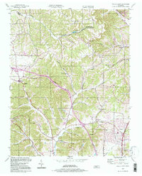
1994 Map of Whites Creek
USGS Topo · Published 1997About this map
Paradise Ridge and Dividing Ridge form the dominant geographic spine of this territory north of Nashville, creating a landscape defined by deep hollows and narrow creek valleys. The settlement at Whites Creek sits at the heart of this network, where the North Fork and South Fork converge. The map illustrates a rural community structured around historic transit corridors like Old Hickory Blvd and Clarksville Pike, connecting small hamlets such as Joelton, Union Hill, and Lickton. Significant local institutions are well-represented, including the Alex Green Sch and several country churches like Spring Hill Ch and Walkers Ch. The presence of the Television Tower (WLAC) and Radio Towers (WLAC) near Ewing reflects the area's mid-century role in regional broadcasting, while landmarks like Devils Elbow highlight the winding, difficult terrain that shaped early road development.
Find a feature on this map
42 named features on this map. Tap any name to fly to it.
Don’t see what you’re looking for? This feature index may not catch every label — zoom into the map to look around manually.
Map Details
Editions of this 1994 Whites Creek Map
This is the sole edition of this map. No revisions or reprints were ever made.
Other maps of this area

1903 · Nashville
USGS Topo · 1:125,000

1931 · Ridgetop
USGS Topo · 1:62,500

1932 · Hermitage
USGS Topo · 1:62,500

1932 · Nashville
USGS Topo · 1:62,500

1935 · Ridgetop
USGS Topo · 1:62,500

1942 · Gallatin
USGS Topo · 1:100,000

1942 · Lebanon
USGS Topo · 1:100,000

1952 · Goodlettsville
USGS Topo · 1:24,000

1952 · Nashville West
USGS Topo · 1:24,000

1952 · Nashville East
USGS Topo · 1:24,000