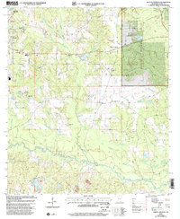
2000 Map of Whites Crossing
USGS Topo · Published 2002About this map
The town of Wiggins serves as the focal point for this Stone County landscape, where the residential grid meets the expanding waters of the Flint Creek Reservoir. To the east, the De Soto National Forest preserves a thicket of wetlands and drainages including Old Cypress Creek and Boggy Branch. The rural character of the area is defined by its numerous community landmarks, such as Stone Sch and Morning Star Ch, which anchored the local social fabric at the turn of the 21st century. Farther south, the terrain follows the winding path of Red Creek, where Sard Ridge Lake and the City Bridge mark important local crossings. The presence of multiple family-named burial sites, including Lott-Hickman Cem and Whites Cem, provides significant data for genealogists tracing the established lineages of this portion of southern Mississippi.
Find a feature on this map
60 named features on this map. Tap any name to fly to it.
Don’t see what you’re looking for? This feature index may not catch every label — zoom into the map to look around manually.
Map Details
Editions of this 2000 Whites Crossing Map
This is the sole edition of this map. No revisions or reprints were ever made.
Other maps of this area

1947 · Wiggins
USGS Topo · 1:62,500

1947 · Benndale
USGS Topo · 1:62,500

1949 · Wiggins
USGS Topo · 1:62,500

1949 · Benndale
USGS Topo · 1:62,500

1953 · Mobile
USGS Topo · 1:250,000

1954 · Vestry
USGS Topo · 1:62,500

1954 · McHenry
USGS Topo · 1:62,500

1957 · Mobile
USGS Topo · 1:250,000

1960 · Mobile
USGS Topo · 1:250,000

1963 · Mobile
USGS Topo · 1:250,000