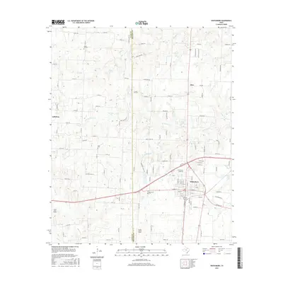
2016 Map of Whitesboro
USGS Topo · Published 2016About this map
Whitesboro serves as the primary hub of this North Texas region, where the residential and commercial street grid is dense with local history. Significant for genealogists, the landscape is dotted with several burial sites, including Whitesboro Cem, Akers Cem, Liberty Hill Cem, and the appropriately named County Line Cem, which sits directly on the border between Cooke and Grayson counties. The area is defined by a network of creeks and small lakes, such as Bing Lake and Harville Lake, which feed into the varied branches of the Big Mineral Creek system.
Find a feature on this map
116 named features on this map. Tap any name to fly to it.
Don’t see what you’re looking for? This feature index may not catch every label — zoom into the map to look around manually.
Map Details
Editions of this 2016 Whitesboro Map
This is the sole edition of this map. No revisions or reprints were ever made.
Other maps of this area

1901 · Denison
USGS Topo · 1:125,000

1902 · Gainesville
USGS Topo · 1:125,000

1943 · Gainesville
USGS Topo · 1:125,000

1954 · Sherman
USGS Topo · 1:250,000

1958 · Gordonville
USGS Topo · 1:62,500

1958 · Whitesboro
USGS Topo · 1:62,500

1958 · Sherman
USGS Topo · 1:250,000

1960 · Callisburg
USGS Topo · 1:24,000

1960 · Woodbine
USGS Topo · 1:24,000
1968 · Horseshoe Bend
USGS Topo · 1:24,000