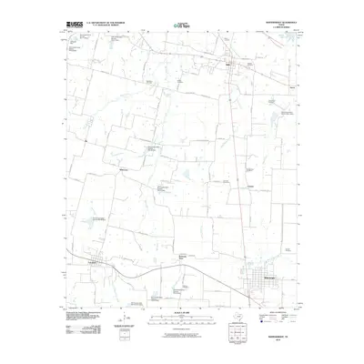
2010 Map of Whitewright
USGS Topo · Published 2010About this map
The agrarian communities of Whitewright and Bells anchor this portion of Grayson County, where the landscape is defined by a dense network of secondary roads and numerous conservation sites managed by the U.S. Department of the Interior. Small settlements like Kentucky Town and Tom Bean reflect the region's historic rural layout, supported by a web of local routes such as Rochell Cannon Rd and Yowell Hill Rd. The terrain is drained by several meandering waterways, including Bois d'Arc Creek and Pilot Grove Creek, which are punctuated by a series of Soil Conservation Service dams and reservoirs like Valley Lake. For genealogists, the map is particularly rich in family-named landmarks and cemeteries, including the Vittitoe, Rosehill, and Washburn burial grounds, providing a precise look at the local history of these East Texas townships.
Find a feature on this map
80 named features on this map. Tap any name to fly to it.
Don’t see what you’re looking for? This feature index may not catch every label — zoom into the map to look around manually.
Map Details
Editions of this 2010 Whitewright Map
This is the sole edition of this map. No revisions or reprints were ever made.
Other maps of this area

1901 · Denison
USGS Topo · 1:125,000

1954 · Sherman
USGS Topo · 1:250,000

1958 · Whitesright
USGS Topo · 1:62,500

1958 · Sherman
USGS Topo · 1:250,000

1958 · Sherman
USGS Topo · 1:62,500

1958 · Sherman
USGS Topo · 1:24,000

1958 · Howe
USGS Topo · 1:24,000

1961 · Van Alstyne
USGS Topo · 1:24,000

1964 · Trenton
USGS Topo · 1:24,000
1964 · Pilot Grove
USGS Topo · 1:24,000