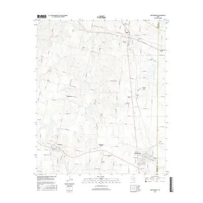
2016 Map of Whitewright
USGS Topo · Published 2016About this map
Whitewright and Bells anchor this portion of the Texas blackland prairies along the Grayson Co Fannin Co line. The map highlights a long-settled agricultural landscape where historical burial grounds like the Ole Vittitoe Rd Kentucky Town Cem and Greenwood Cem mark the heritage of the surrounding countryside. Smaller hubs such as Kentucky Town, Tom Bean, and Savoy are connected by a network of farm-to-market roads and rural routes like Gospel Ridge Rd. The terrain is defined by the drainage patterns of Bois d'Arc Cr and the W Fork Pilot Grove Cr, which cut through the rolling fields. Aviation history is also present through several private airstrips, including Pritchard Airport and Mag Drop Airport, indicating the modern utility of these open North Texas lands.
Find a feature on this map
135 named features on this map. Tap any name to fly to it.
Don’t see what you’re looking for? This feature index may not catch every label — zoom into the map to look around manually.
Map Details
Editions of this 2016 Whitewright Map
This is the sole edition of this map. No revisions or reprints were ever made.
Other maps of this area

1901 · Denison
USGS Topo · 1:125,000

1954 · Sherman
USGS Topo · 1:250,000

1958 · Whitesright
USGS Topo · 1:62,500

1958 · Sherman
USGS Topo · 1:250,000

1958 · Sherman
USGS Topo · 1:62,500

1958 · Sherman
USGS Topo · 1:24,000

1958 · Howe
USGS Topo · 1:24,000

1961 · Van Alstyne
USGS Topo · 1:24,000

1964 · Trenton
USGS Topo · 1:24,000
1964 · Pilot Grove
USGS Topo · 1:24,000