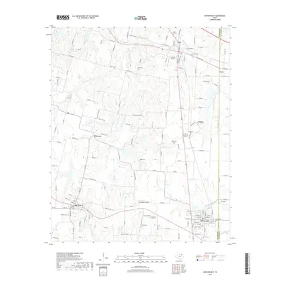
2019 Map of Whitewright
USGS Topo · Published 2019About this map
Kentucky Town and the surrounding prairie of the Grayson Co and Fannin Co border define this survey of northern Texas. The landscape is a network of small agricultural settlements and family burial grounds, such as Batsell Cem and Vittitoe Cem, connected by a grid of farm-to-market roads and local lanes like Gospel Ridge Rd. The terrain is drained by several prominent waterways, most notably Bois d'Arc Cr and Mill Cr, which carve through the undulating plains between Bells and Whitewright. Small aviation strips like Pritchard Airport and Mag-Drop Airport indicate the modern character of these rural communities. Genealogists will find significant value in the high density of small cemeteries, including Rosehill Cem and Kentucky Town Cem, which anchor the history of these established ranching and farming districts.
Find a feature on this map
129 named features on this map. Tap any name to fly to it.
Don’t see what you’re looking for? This feature index may not catch every label — zoom into the map to look around manually.
Map Details
Editions of this 2019 Whitewright Map
This is the sole edition of this map. No revisions or reprints were ever made.
Other maps of this area

1901 · Denison
USGS Topo · 1:125,000

1954 · Sherman
USGS Topo · 1:250,000

1958 · Whitesright
USGS Topo · 1:62,500

1958 · Sherman
USGS Topo · 1:250,000

1958 · Sherman
USGS Topo · 1:62,500

1958 · Sherman
USGS Topo · 1:24,000

1958 · Howe
USGS Topo · 1:24,000

1961 · Van Alstyne
USGS Topo · 1:24,000

1964 · Trenton
USGS Topo · 1:24,000
1964 · Pilot Grove
USGS Topo · 1:24,000