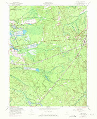
1957 Map of Whiting
USGS Topo · Published 1971About this map
Fort Dix Military Reservation and Lebanon State Forest dominate this landscape in the mid-20th century, where the Pine Barrens of Manchester and Woodland townships are marked by cranberry agriculture and military boundaries. The settlement of Whiting serves as a central hub, where the Penn Central tracks intersect with the rural road network. Smaller, isolated communities such as Roosevelt City, Buckingham, and Wheatland (Pasadena) are scattered among the dense waterways, including the three branches of Mount Misery Brook and the Pole Bridge Branch. The presence of several Cranberry Bogs near the Pemberton border illustrates the specialized agricultural history of this region. This survey captures a moment before modern development, preserving the locations of the Manchester Sch and old transit corridors like Central Jersey Road.
Find a feature on this map
36 named features on this map. Tap any name to fly to it.
Don’t see what you’re looking for? This feature index may not catch every label — zoom into the map to look around manually.
Map Details
Editions of this 1957 Whiting Map
4 editions found
Other maps of this area

1884 · Whitings
USGS Topo · 1:62,500

1888 · Bordentown
USGS Topo · 1:62,500

1888 · Pemberton
USGS Topo · 1:62,500

1888 · Cassville
USGS Topo · 1:62,500

1888 · Whitings
USGS Topo · 1:62,500

1893 · Bordentown
USGS Topo · 1:62,500

1894 · Cassville
USGS Topo · 1:62,500

1894 · Pemberton
USGS Topo · 1:62,500

1898 · Pemberton
USGS Topo · 1:62,500

1900 · Cassville
USGS Topo · 1:62,500
Featured Places
- Jackson Township, NJ
- Manchester Township, NJ
- Lacey Township, NJ
- Plumsted Township, NJ
- Cedar Glen Lakes, Manchester Township