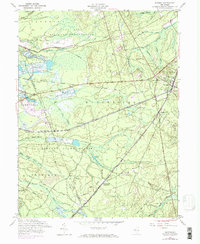
1957 Map of Whiting
USGS Topo · Published 1971About this map
Whiting serves as a central hub for the rail lines and forest roads traversing this section of the New Jersey Pine Barrens. The landscape is defined by the intersection of the Central Railroad of New Jersey and the Penn Central, which cut through the dense acreage of Lebanon State Forest. To the north, the Fort Dix Military Reservation establishes a significant military presence, while several dispersed settlements like Roosevelt City and Wheatland (Pasadena) are tucked into the woods.
Find a feature on this map
33 named features on this map. Tap any name to fly to it.
Don’t see what you’re looking for? This feature index may not catch every label — zoom into the map to look around manually.
Map Details
Editions of this 1957 Whiting Map
4 editions found
Other maps of this area

1884 · Whitings
USGS Topo · 1:62,500

1888 · Bordentown
USGS Topo · 1:62,500

1888 · Pemberton
USGS Topo · 1:62,500

1888 · Cassville
USGS Topo · 1:62,500

1888 · Whitings
USGS Topo · 1:62,500

1893 · Bordentown
USGS Topo · 1:62,500

1894 · Cassville
USGS Topo · 1:62,500

1894 · Pemberton
USGS Topo · 1:62,500

1898 · Pemberton
USGS Topo · 1:62,500

1900 · Cassville
USGS Topo · 1:62,500
Featured Places
- Jackson Township, NJ
- Manchester Township, NJ
- Lacey Township, NJ
- Plumsted Township, NJ
- Cedar Glen Lakes, Manchester Township