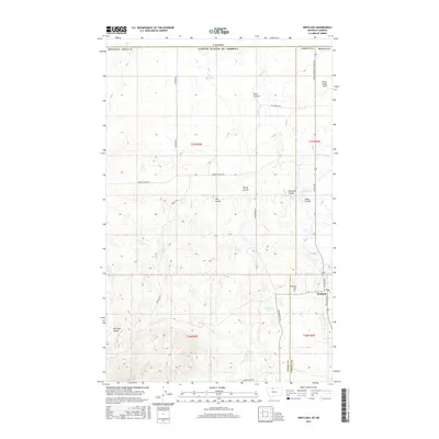
2017 Map of Whitlash
USGS Topo · Published 2017About this map
Whitlash stands as the primary settlement on this northern Montana landscape, located just south of the Canadian border where Toole and Liberty Counties meet. The terrain is defined by the high, rolling topography of the Sweet Grass Hills, carved by a complex network of coulees including Kent Coulee and Spring Coulee. Water management is central to the land's utility, evidenced by a series of man-made catchments like Cook Reservoir, Brown Reservoir, and Morris Reservoir. For genealogists, the Whitlash Cem provides a specific point of local history near the junction of Whitlash Rd and Co Rd 409, which serves as a port of entry. The layout of ranch roads like Strawberry Rd and Gardner Rd illustrates the remote, agrarian transport patterns of this borderland region.
Find a feature on this map
32 named features on this map. Tap any name to fly to it.
Don’t see what you’re looking for? This feature index may not catch every label — zoom into the map to look around manually.
Map Details
Editions of this 2017 Whitlash Map
This is the sole edition of this map. No revisions or reprints were ever made.
Other maps of this area

1954 · Shelby
USGS Topo · 1:250,000

1958 · Shelby
USGS Topo · 1:250,000

1962 · Whitlash
USGS Topo · 1:24,000

1962 · Cameron Lake
USGS Topo · 1:24,000

1962 · Fey Lakes
USGS Topo · 1:24,000
1962 · Hawley Hill
USGS Topo · 1:24,000

1962 · Haystack Butte
USGS Topo · 1:24,000

1962 · Grassy Butte
USGS Topo · 1:24,000

1984 · Sweet Grass Hills
USGS Topo · 1:100,000
2011 · Fey Lakes
USGS Topo · 1:24,000