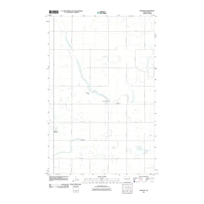
2011 Map of Whitman
USGS Topo · Published 2011About this map
Whitman anchors the southwestern corner of this landscape in eastern North Dakota, situated within a grid of section-line roads that define the region's agricultural character. The drainage of the Middle Branch Forest River winds through the center of the map, held back in several places by infrastructure projects. Key landmarks include the Whitman Dam and the Sarnia Dam, which manage the water flow across this prairie terrain. Genealogists and local historians will find the East Sarnia Cemetery located along 53rd St NE, a significant site for tracing family ties in the surrounding township. The network of county routes, such as County Rd 11, connects the scattered farmsteads and water features that represent the area's twentieth-century development.
Find a feature on this map
21 named features on this map. Tap any name to fly to it.
Don’t see what you’re looking for? This feature index may not catch every label — zoom into the map to look around manually.
Map Details
Editions of this 2011 Whitman Map
This is the sole edition of this map. No revisions or reprints were ever made.
Other maps of this area

1952 · Thief River Falls
USGS Topo · 1:250,000

1953 · Devils Lake
USGS Topo · 1:250,000

1956 · Thief River Falls
USGS Topo · 1:250,000

1956 · Devils Lake
USGS Topo · 1:250,000

1957 · Thief River Falls
USGS Topo · 1:250,000

1967 · Thief River Falls
USGS Topo · 1:250,000

1971 · Michigan West
USGS Topo · 1:24,000
1971 · Michigan East
USGS Topo · 1:24,000
1971 · Fordville SW
USGS Topo · 1:24,000

1971 · Whitman
USGS Topo · 1:24,000