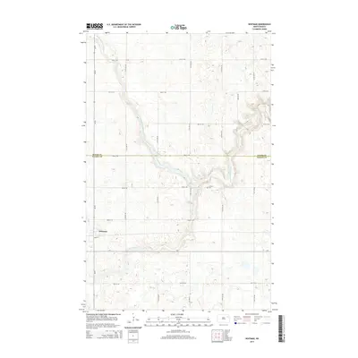
2014 Map of Whitman
USGS Topo · Published 2014About this map
Whitman sits at the heart of this Nelson County landscape, where the prairie grid is defined by a network of local roads and sections. The town's layout is grounded by Main St S, reflecting a classic North Dakota settlement pattern centered on regional connectivity. North of the town center, the Middle Branch Forest River carves a distinct path through the terrain, its course also identified as the Middle Br Forest River as it winds toward the boundary shared by Walsh and Nelson Counties. This drainage system creates the most significant topographical variation in an otherwise agricultural expanse. Nearby, the E Sarnia Cem serves as a vital touchstone for local genealogy, situated along 53rd St NE east of the river valley. The map documents a quiet period of rural continuity, where county routes like Co Road 11 and Cr-1 facilitate the movement of people and goods across the Red River Valley hinterlands.
Find a feature on this map
24 named features on this map. Tap any name to fly to it.
Don’t see what you’re looking for? This feature index may not catch every label — zoom into the map to look around manually.
Map Details
Editions of this 2014 Whitman Map
This is the sole edition of this map. No revisions or reprints were ever made.
Other maps of this area

1952 · Thief River Falls
USGS Topo · 1:250,000

1953 · Devils Lake
USGS Topo · 1:250,000

1956 · Thief River Falls
USGS Topo · 1:250,000

1956 · Devils Lake
USGS Topo · 1:250,000

1957 · Thief River Falls
USGS Topo · 1:250,000

1967 · Thief River Falls
USGS Topo · 1:250,000

1971 · Michigan West
USGS Topo · 1:24,000
1971 · Michigan East
USGS Topo · 1:24,000
1971 · Fordville SW
USGS Topo · 1:24,000

1971 · Whitman
USGS Topo · 1:24,000