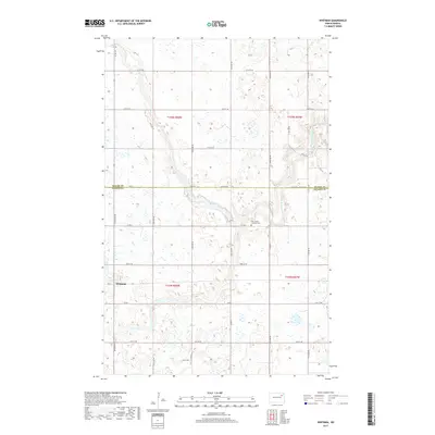
2017 Map of Whitman
USGS Topo · Published 2017About this map
The small settlement of Whitman sits in the heart of this agricultural landscape in Nelson County, where the plains are etched by the winding path of the Middle Br Forest River. This map reveals a high-density grid of section roads and avenues, such as 115th Ave NE and 57th St NE, that define the region's township-and-range development. A notable cultural landmark is the East Sarnia Lutheran Cem, located along Co Rd 2, serving as a silent record of the area's pioneer heritage and Scandinavian-American roots. The boundary line between Walsh Co and Nelson Co bisects the northern reaches of the sheet, following the path of 54th St and the 54th St NE Prairie Trl, illustrating how early administrative borders were often tied directly to the utilitarian survey grid.
Find a feature on this map
30 named features on this map. Tap any name to fly to it.
Don’t see what you’re looking for? This feature index may not catch every label — zoom into the map to look around manually.
Map Details
Editions of this 2017 Whitman Map
This is the sole edition of this map. No revisions or reprints were ever made.
Other maps of this area

1952 · Thief River Falls
USGS Topo · 1:250,000

1953 · Devils Lake
USGS Topo · 1:250,000

1956 · Thief River Falls
USGS Topo · 1:250,000

1956 · Devils Lake
USGS Topo · 1:250,000

1957 · Thief River Falls
USGS Topo · 1:250,000

1967 · Thief River Falls
USGS Topo · 1:250,000

1971 · Michigan West
USGS Topo · 1:24,000
1971 · Michigan East
USGS Topo · 1:24,000
1971 · Fordville SW
USGS Topo · 1:24,000

1971 · Whitman
USGS Topo · 1:24,000