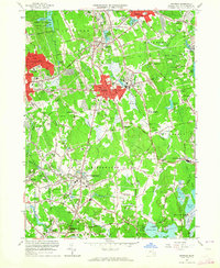
1962 Map of Whitman
USGS Topo · Published 1964About this map
The northern reaches of the Satucket River drainage define the landscape of this 1962 survey, which covers the industrial and residential heart of Plymouth County. Significant urban density is visible in Whitman and Rockland, while the eastern portion of Brockton shows the city's mid-century expansion. The map captures an era of post-war educational growth, evidenced by the large campus of Whitman-Hanson Regional High Sch and several parish-based institutions like St Bridgets Sch. The industrial heritage of the region is reflected in the numerous Cranberry Bogs dotting the lowlands near Burrage Pond and the extensive network of the New York New Haven and Hartford railroad lines. Recreational and conservation spaces are also well-established, including the expansive Ames Nowell State Park and the centrally located Island Grove Park.
Find a feature on this map
112 named features on this map. Tap any name to fly to it.
Don’t see what you’re looking for? This feature index may not catch every label — zoom into the map to look around manually.
Map Details
Editions of this 1962 Whitman Map
2 editions found
Other maps of this area

1885 · Abington
USGS Topo · 1:62,500

1885 · Middleboro
USGS Topo · 1:62,500

1885 · Taunton
USGS Topo · 1:62,500

1886 · Dedham
USGS Topo · 1:62,500

1888 · Taunton
USGS Topo · 1:62,500

1888 · Middleboro
USGS Topo · 1:62,500

1888 · Abington
USGS Topo · 1:62,500

1893 · Abington
USGS Topo · 1:62,500

1893 · Taunton
USGS Topo · 1:62,500

1893 · Middleboro
USGS Topo · 1:62,500