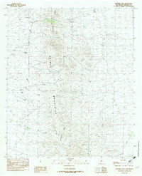
1982 Map of Whitmire Pass
USGS Topo · Published 1982About this map
The Continental Divide runs directly through this portion of the high-elevation Animas Mountains, marking a primary hydrological boundary in the southwestern corner of New Mexico. Recorded as a provisional edition in the early 1980s, the landscape is defined by its isolation and lack of permanent settlements, focused instead on the topographical transit through Whitmire Pass. The map highlights a series of drainages, including Whitmire Creek and Willow Creek, which carve through the steep terrain. Scattered mineral interests are evident through labels for several Prospects and a singular Prospect located near the peaks. Access to this remote environment is primarily restricted to a Jeep Trail, illustrating the limited development and focus on resource exploration rather than habitation during this era.
Find a feature on this map
13 named features on this map. Tap any name to fly to it.
Don’t see what you’re looking for? This feature index may not catch every label — zoom into the map to look around manually.
Map Details
Editions of this 1982 Whitmire Pass Map
This is the sole edition of this map. No revisions or reprints were ever made.
Other maps of this area

1918 · Walnut Wells
USGS Topo · 1:62,500

1918 · Playas
USGS Topo · 1:62,500

1918 · Animas Peak
USGS Topo · 1:62,500

1918 · Pratt
USGS Topo · 1:62,500

1919 · Pratt
USGS Topo · 1:62,500

1919 · Playas
USGS Topo · 1:62,500

1920 · Animas Peak
USGS Topo · 1:62,500

1923 · Walnut Wells
USGS Topo · 1:62,500

1955 · Douglas
USGS Topo · 1:250,000

1959 · Douglas
USGS Topo · 1:250,000