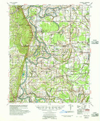
1956 Map of Whitmore
USGS Topo · Published 1957About this map
The St Francis River meanders through the heart of this mid-1950s landscape, defining the boundaries and economic life of St. Francis and Cross counties. The river's dramatic bends, including Gray Bend and Merriman Bend, frame a floodplain dotted with named oxbows like Kiechley Lake and Horseshoe Lake. The survey highlights a highly developed network of rural communities and social institutions, with Wittsburg and Madison serving as focal points. The map is particularly rich for genealogical research, documenting numerous small congregations and burial grounds such as Shiloh Ch & Cem and Harris Chapel Ch & Cem.
Find a feature on this map
139 named features on this map. Tap any name to fly to it.
Don’t see what you’re looking for? This feature index may not catch every label — zoom into the map to look around manually.
Map Details
Editions of this 1956 Whitmore Map
This is the sole edition of this map. No revisions or reprints were ever made.
Other maps of this area

1931 · Horseshoe Lake
USGS Topo · 1:62,500
1939 · Vanndale
USGS Topo · 1:62,500
1939 · Horseshoe Lake
USGS Topo · 1:62,500
1939 · Park Place
USGS Topo · 1:62,500
1939 · Wynne
USGS Topo · 1:62,500

1939 · Edmondson
USGS Topo · 1:62,500

1940 · Deckerville
USGS Topo · 1:62,500
1940 · Princedale
USGS Topo · 1:62,500

1940 · Whitmore
USGS Topo · 1:62,500
1940 · Marianna
USGS Topo · 1:62,500