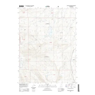
2014 Map of Whitney Reservoir
USGS Topo · Published 2014About this map
The Mill City Ghost Town sits along the W Fork Bear River, a quiet reminder of early industry within the Wasatch National Forest. This high-elevation terrain is defined by a complex network of alpine lakes and dramatic summits, including Moffit Peak and Gold Hill. The central Whitney Reservoir is fed by Meadow Cr and Humpy Cr, while the southern reaches of the map show the headwaters of the Weber River and the Hayden Fork. Several lakes with distinctive names, such as Whiskey Island Lake, Bourbon Lake, and Fish Lake, are scattered across the high basins. For researchers, the map provides a look at the remote access routes of the modern era, tracing Whitney Rd and State Hwy 150 as they navigate through passes like Moffit Pass and Gold Hill Pass to connect these high-country landmarks.
Find a feature on this map
34 named features on this map. Tap any name to fly to it.
Don’t see what you’re looking for? This feature index may not catch every label — zoom into the map to look around manually.
Map Details
Editions of this 2014 Whitney Reservoir Map
This is the sole edition of this map. No revisions or reprints were ever made.
Other maps of this area

1885 · Salt Lake
USGS Topo · 1:250,000

1885 · Uinta
USGS Topo · 1:250,000

1900 · Coalville
USGS Topo · 1:125,000

1901 · Hayden Peak
USGS Topo · 1:125,000

1903 · Hayden Peak
USGS Topo · 1:125,000

1903 · Coalville
USGS Topo · 1:125,000

1954 · Salt Lake City
USGS Topo · 1:250,000

1958 · Salt Lake City
USGS Topo · 1:250,000

1960 · Salt Lake City
USGS Topo · 1:250,000
1972 · Seven Tree Flat
USGS Topo · 1:24,000