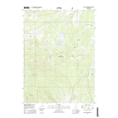
2017 Map of Whitney Reservoir
USGS Topo · Published 2017About this map
The Wasatch National Forest dominates this high-altitude landscape, where the headwaters of several major drainages originate. At its center, the Whitney Reservoir sits as a primary hydrological feature, surrounded by a complex network of creeks including Meadow Cr and the W Fork Bear River. The terrain is characterized by a series of significant peaks and passes, such as Moffit Peak and Gold Hill Pass, which dictated the early travel routes and modern recreation paths through the mountains.
Find a feature on this map
43 named features on this map. Tap any name to fly to it.
Don’t see what you’re looking for? This feature index may not catch every label — zoom into the map to look around manually.
Map Details
Editions of this 2017 Whitney Reservoir Map
This is the sole edition of this map. No revisions or reprints were ever made.
Other maps of this area

1885 · Salt Lake
USGS Topo · 1:250,000

1885 · Uinta
USGS Topo · 1:250,000

1900 · Coalville
USGS Topo · 1:125,000

1901 · Hayden Peak
USGS Topo · 1:125,000

1903 · Hayden Peak
USGS Topo · 1:125,000

1903 · Coalville
USGS Topo · 1:125,000

1954 · Salt Lake City
USGS Topo · 1:250,000

1958 · Salt Lake City
USGS Topo · 1:250,000

1960 · Salt Lake City
USGS Topo · 1:250,000
1972 · Seven Tree Flat
USGS Topo · 1:24,000