
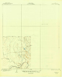
1930 Map of Whitsett
USGS Topo · Published 1930About this map
The Frio River meanders through the southern reaches of this South Texas landscape, joined by a drainage network of creeks that define the local topography. This 1930 edition, based on 1925 surveys, is notable for its use of early aerial photography from the U.S. Army Air Corps to compile cultural and drainage data. The small settlement of Crowther stands at a central junction of local tracks, positioned just north of the prominent Opossum Hill. The map is characterized by a significant area marked as a Preliminary Edition Unsurveyed Area to the north and east, leaving only the southwestern portion of the quadrangle with detailed contour data. This partial detail emphasizes the winding paths of San Miguel Creek and Elm Creek as they flow toward the Frio, providing a unique look at the rural landscape before more comprehensive modern surveys were completed.
Find a feature on this map
8 named features on this map. Tap any name to fly to it.
Don’t see what you’re looking for? This feature index may not catch every label — zoom into the map to look around manually.
Map Details
Editions of this 1930 Whitsett Map
2 editions found
Other maps of this area

1920 · Mikeska
USGS Topo · 1:125,000

1925 · Simmons No. 1
USGS Topo · 1:48,000

1925 · Tilden No. 1
USGS Topo · 1:48,000

1925 · Crowther No. 3
USGS Topo · 1:48,000

1925 · Simmons No. 2
USGS Topo · 1:48,000

1927 · Oakville
USGS Topo · 1:62,500

1929 · Simmons
USGS Topo · 1:62,500

1930 · Tilden
USGS Topo · 1:62,500

1931 · Falls City
USGS Topo · 1:62,500

1942 · Tilden
USGS Topo · 1:62,500