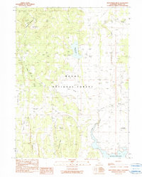
1990 Map of Whittemore Ridge
USGS Topo · Published 1990About this map
Modoc National Forest encompasses the high volcanic plateaus and valleys shown in this 1990 provisional survey. The landscape is defined by its water management systems and natural springs, crucial for ranching and forest maintenance. To the south, the expansive Big Sage Reservoir dominates the basin, while the Dorris Brothers Reservoir and Ingall Swamp characterize the central drainage. This map documents a series of critical watering points, such as Whittemore Spring, Logan Spring, and several stock tanks including the Timbered Mountain Stock Tank and DeCamp Stock Tank. The relief is marked by Timbered Mountain and the distinct Porcupine Rim overlooking Williams Valley. These features reflect the area's long-standing utility for grazing and resource management within the high desert environment of Northeastern California.
Find a feature on this map
20 named features on this map. Tap any name to fly to it.
Don’t see what you’re looking for? This feature index may not catch every label — zoom into the map to look around manually.
Map Details
Editions of this 1990 Whittemore Ridge Map
This is the sole edition of this map. No revisions or reprints were ever made.
Other maps of this area

1886 · Alturas
USGS Topo · 1:250,000

1892 · Alturas
USGS Topo · 1:250,000

1954 · Alturas
USGS Topo · 1:250,000

1958 · Alturas
USGS Topo · 1:250,000

1962 · Alturas
USGS Topo · 1:250,000

1962 · Big Sage Reservoir
USGS Topo · 1:62,500

1962 · Steele Swamp
USGS Topo · 1:62,500

1962 · South Mountain
USGS Topo · 1:62,500

1962 · Jacks Butte
USGS Topo · 1:62,500

1965 · Alturas
USGS Topo · 1:250,000