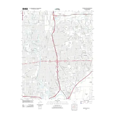
2012 Map of Wichita East
USGS Topo · Published 2012About this map
Arkansas River and Little Arkansas River converge near the heart of this urban survey, framing a landscape defined by significant institutional and industrial heritage. The city’s history is preserved at Cow Town on the riverbank, while the southeastern corner is dominated by the sprawling Mc Connell Air Force Base and the Cessna Aircraft Field Airport, reflecting the region's deep connection to aviation. For genealogists, the map is remarkably dense with burial grounds, including Old Mission Cem, Wichita Hebrew Cem, and Highland Cem, alongside the White Chapel Memorial Gardens. Major academic centers such as Wichita State Univ and the Univ of Kansas Sch of Medicine Wichita are clearly delineated, as is the residential enclave of Eastborough. Transportation infrastructure, from Hardtner Junction to the Murray Bridge, illustrates the complex network supporting this Kansas hub.
Find a feature on this map
116 named features on this map. Tap any name to fly to it.
Don’t see what you’re looking for? This feature index may not catch every label — zoom into the map to look around manually.
Map Details
Editions of this 2012 Wichita East Map
This is the sole edition of this map. No revisions or reprints were ever made.
Other maps of this area

1889 · Wichita
USGS Topo · 1:125,000

1894 · Wichita
USGS Topo · 1:125,000

1941 · Maize
USGS Topo · 1:31,680

1941 · Valley Center
USGS Topo · 1:31,680

1942 · Valley Center
USGS Topo · 1:31,680

1942 · Maize
USGS Topo · 1:31,680

1943 · Wichita West
USGS Topo · 1:31,680

1943 · Wichita East
USGS Topo · 1:31,680

1943 · Derby
USGS Topo · 1:31,680

1943 · Bayneville
USGS Topo · 1:31,680