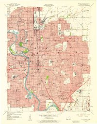
1956 Map of Wichita East
USGS Topo · Published 1957About this map
The Arkansas River and Little Arkansas River converge in a landscape defined by rapid mid-century urban expansion and industrial development. This survey reveals a dense grid of residential neighborhoods, schools, and parks punctuated by significant institutions like Wichita University and Friends University. The eastern outskirts show the footprint of aviation and defense, anchored by McConnell Air Force Base and the Cessna Landing Field.
Find a feature on this map
142 named features on this map. Tap any name to fly to it.
Don’t see what you’re looking for? This feature index may not catch every label — zoom into the map to look around manually.
Map Details
Editions of this 1956 Wichita East Map
This is the sole edition of this map. No revisions or reprints were ever made.
Other maps of this area

1889 · Wichita
USGS Topo · 1:125,000

1894 · Wichita
USGS Topo · 1:125,000

1941 · Maize
USGS Topo · 1:31,680

1941 · Valley Center
USGS Topo · 1:31,680

1942 · Valley Center
USGS Topo · 1:31,680

1942 · Maize
USGS Topo · 1:31,680

1943 · Wichita West
USGS Topo · 1:31,680

1943 · Wichita East
USGS Topo · 1:31,680

1943 · Derby
USGS Topo · 1:31,680

1943 · Bayneville
USGS Topo · 1:31,680