1985 Map of Wichita
USGS Topo · Published 1985About this map
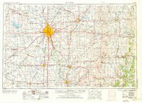
The Arkansas River and Little Arkansas River converge in the heart of Wichita, anchoring a landscape defined by aviation and water management in the mid-1980s. This survey reveals a mature metropolitan footprint surrounded by outlying communities like Haysville, Derby, and Valley Center. To the west, the Cheney Reservoir and its associated Cheney Reservoir State Wildlife Area dominate the border of Reno and Sedgwick counties, highlighting the regional importance of water resources. Aviation history is visible through the concentration of airfields, from McConnell Air Force Base to corporate and municipal sites like Cessna Aircraft Field and Mid-Continent Airport. The intricate web of railroads, including the Santa Fe and Frisco lines, underscores the city's role as a transport hub, while local genealogy is grounded by sites like White Chapel Cem and Resthaven Cem.
Find a feature on this map
171 named features on this map. Tap any name to fly to it.
Don’t see what you’re looking for? This feature index may not catch every label — zoom into the map to look around manually.
Map Details
Editions of this 1985 Wichita Map
This is the sole edition of this map. No revisions or reprints were ever made.
Historical Maps of Wichita Through Time
6 maps found