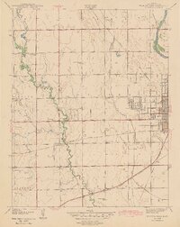
1943 Map of Wichita West
USGS Topo · Published 1943About this map
Wichita expands westward toward the meandering Cowskin Creek in this early 1940s landscape, where the transition from urban streets to rural section lines is sharply defined. The eastern edge is anchored by the Arkansas River and the bustling grid of the city, including institutional landmarks like the County Hospital, Mount Carmel Academy, and Eugene Field Sch. Moving west into Delano and Attica townships, the landscape opens into a network of small school districts and agricultural settlements.
Find a feature on this map
35 named features on this map. Tap any name to fly to it.
Don’t see what you’re looking for? This feature index may not catch every label — zoom into the map to look around manually.
Map Details
Editions of this 1943 Wichita West Map
2 editions found
Other maps of this area

1889 · Cheney
USGS Topo · 1:125,000

1889 · Wichita
USGS Topo · 1:125,000

1891 · Cheney
USGS Topo · 1:125,000

1894 · Wichita
USGS Topo · 1:125,000

1901 · Cheney
USGS Topo · 1:125,000

1941 · Maize
USGS Topo · 1:31,680

1941 · Valley Center
USGS Topo · 1:31,680

1942 · Valley Center
USGS Topo · 1:31,680

1942 · Maize
USGS Topo · 1:31,680

1943 · Wichita West
USGS Topo · 1:31,680