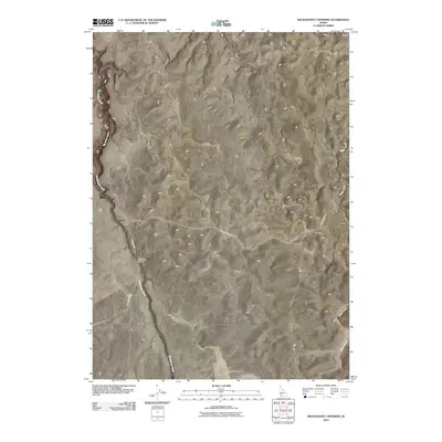
2010 Map of Wickahoney Crossing
USGS Topo · Published 2010About this map
Wickahoney Crossing serves as the central landmark for this arid corner of Owyhee County, where local desert roads intersect amid a landscape defined by deep drainage systems. The sparse road network, featuring Battle Creek Rd and Sheep Creek Rd, follows the natural contours of the high plateau, illustrating how transportation in this part of Idaho remains tied to the few viable passage points over watercourses. The map traces the winding paths of Big Jacks Creek and Wickahoney Creek as they cut through the terrain, alongside Sugar Creek in the eastern section. This 2010 survey reflects a period of modern mapping that preserves traditional ranching and backcountry routes, highlighting the enduring spatial relationships between these remote water sources and the primitive road corridors that have served the region for generations.
Find a feature on this map
6 named features on this map. Tap any name to fly to it.
Don’t see what you’re looking for? This feature index may not catch every label — zoom into the map to look around manually.
Map Details
Editions of this 2010 Wickahoney Crossing Map
This is the sole edition of this map. No revisions or reprints were ever made.
Other maps of this area

1955 · Jordan Valley
USGS Topo · 1:250,000

1955 · Twin Falls
USGS Topo · 1:250,000

1956 · Big Hill
USGS Topo · 1:62,500

1957 · Jordan Valley
USGS Topo · 1:250,000

1958 · Twin Falls
USGS Topo · 1:250,000

1958 · Jordan Valley
USGS Topo · 1:250,000
1972 · Hill Pasture
USGS Topo · 1:24,000

1972 · Wickahoney Point
USGS Topo · 1:24,000
1972 · Big Horse Basin Gap
USGS Topo · 1:24,000

1979 · Blackstone Reservoir
USGS Topo · 1:24,000