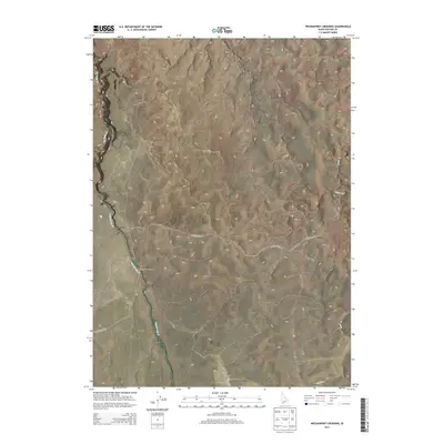
2013 Map of Wickahoney Crossing
USGS Topo · Published 2013About this map
Wickahoney Crossing serves as the focal point of this high-desert landscape in Owyhee County, situated at a junction of historical movement where early roads met the drainage of Wickahoney Cr. The map reveals a remote pastoral environment defined by deep-cut stream channels and expansive tablelands, typical of the Idaho plateau country. Long-established transportation routes like Battle Creek Rd and Sheep Creek Rd traverse the townships, providing access through a terrain marked by the seasonal flows of Big Jacks Cr and Sugar Cr. The sparse infrastructure and lack of modern development highlight the area's continued use for ranching and open-range activities, where water sources and established crossings remain the primary landmarks for navigation.
Find a feature on this map
12 named features on this map. Tap any name to fly to it.
Don’t see what you’re looking for? This feature index may not catch every label — zoom into the map to look around manually.
Map Details
Editions of this 2013 Wickahoney Crossing Map
This is the sole edition of this map. No revisions or reprints were ever made.
Other maps of this area

1955 · Jordan Valley
USGS Topo · 1:250,000

1955 · Twin Falls
USGS Topo · 1:250,000

1956 · Big Hill
USGS Topo · 1:62,500

1957 · Jordan Valley
USGS Topo · 1:250,000

1958 · Twin Falls
USGS Topo · 1:250,000

1958 · Jordan Valley
USGS Topo · 1:250,000
1972 · Hill Pasture
USGS Topo · 1:24,000

1972 · Wickahoney Point
USGS Topo · 1:24,000
1972 · Big Horse Basin Gap
USGS Topo · 1:24,000

1979 · Blackstone Reservoir
USGS Topo · 1:24,000