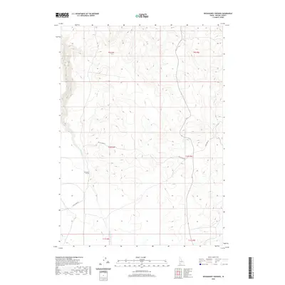
2020 Map of Wickahoney Crossing
USGS Topo · Published 2020About this map
Wickahoney Crossing serves as a central landmark in this high-desert portion of Owyhee County, where local travel is defined by a network of gravel and 4WD tracks. These routes, including Battle Creek Rd and Sheep Creek Rd, navigate the plateau between deeply incised drainages. The landscape is carved by the intermittent flows of Wickahoney Cr and Big Jacks Cr, while the eastern portion of the map is shaped by the drainage of Sugar Cr. The presence of the CCC Rd suggests the historical footprint of the Civilian Conservation Corps in managing this arid environment. This topography remains primarily focused on ranching and rangeland management, with large tracts defined by the Rectangular Survey System sections of Township 10 South and surrounding ranges.
Find a feature on this map
13 named features on this map. Tap any name to fly to it.
Don’t see what you’re looking for? This feature index may not catch every label — zoom into the map to look around manually.
Map Details
Editions of this 2020 Wickahoney Crossing Map
This is the sole edition of this map. No revisions or reprints were ever made.
Other maps of this area

1955 · Jordan Valley
USGS Topo · 1:250,000

1955 · Twin Falls
USGS Topo · 1:250,000

1956 · Big Hill
USGS Topo · 1:62,500

1957 · Jordan Valley
USGS Topo · 1:250,000

1958 · Twin Falls
USGS Topo · 1:250,000

1958 · Jordan Valley
USGS Topo · 1:250,000
1972 · Hill Pasture
USGS Topo · 1:24,000

1972 · Wickahoney Point
USGS Topo · 1:24,000
1972 · Big Horse Basin Gap
USGS Topo · 1:24,000

1979 · Blackstone Reservoir
USGS Topo · 1:24,000