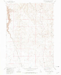
1980 Map of Wickahoney Crossing
USGS Topo · Published 1981About this map
Wickahoney Creek carves a deep path through the high desert of Owyhee County, defining the drainage patterns in this corner of Idaho. The landscape is dominated by the broad prominence of Big Hill, where the topography reflects a high-altitude plateau crisscrossed by a network of Jeep Trails and a historic Pack Trail. These routes speak to the legacy of land management and recreation in a region where water sources are few and far between.
Find a feature on this map
10 named features on this map. Tap any name to fly to it.
Don’t see what you’re looking for? This feature index may not catch every label — zoom into the map to look around manually.
Map Details
Editions of this 1980 Wickahoney Crossing Map
This is the sole edition of this map. No revisions or reprints were ever made.
Other maps of this area

1955 · Jordan Valley
USGS Topo · 1:250,000

1955 · Twin Falls
USGS Topo · 1:250,000

1956 · Big Hill
USGS Topo · 1:62,500

1957 · Jordan Valley
USGS Topo · 1:250,000

1958 · Twin Falls
USGS Topo · 1:250,000

1958 · Jordan Valley
USGS Topo · 1:250,000
1972 · Hill Pasture
USGS Topo · 1:24,000

1972 · Wickahoney Point
USGS Topo · 1:24,000
1972 · Big Horse Basin Gap
USGS Topo · 1:24,000

1979 · Blackstone Reservoir
USGS Topo · 1:24,000