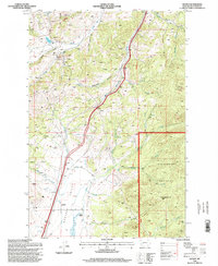
1996 Map of Wickes
USGS Topo · Published 1998About this map
Alta Mountain stands over a landscape defined by decades of mineral exploration and high-mountain ranching in Jefferson County. During this mid-1990s revision, the terrain is marked by a high density of mining activity, including a prominent Mine Shaft, an Open Pit Mine, and dozens of individual Prospects clustered near the settlements of Wickes and Amazon. The drainage network, featuring Prickly Pear Creek and its many tributaries like Iron Ore Gulch and Beaverton Gulch, dictates the movement through the Boulder Hills. In the lower Boulder Valley, the agricultural footprint remains visible at Sloan Ranch and Rieder, where a complex system of Ditches and canals manages the water supply. Large portions of the eastern terrain are protected within the Deerlodge National Forest, where the topography rises toward Turkey Park.
Find a feature on this map
36 named features on this map. Tap any name to fly to it.
Don’t see what you’re looking for? This feature index may not catch every label — zoom into the map to look around manually.
Map Details
Editions of this 1996 Wickes Map
This is the sole edition of this map. No revisions or reprints were ever made.
Other maps of this area

1886 · Fort Logan
USGS Topo · 1:250,000

1889 · Helena
USGS Topo · 1:250,000

1893 · Helena
USGS Topo · 1:250,000

1899 · Boulder
USGS Topo · 1:125,000

1899 · Helena
USGS Topo · 1:250,000

1903 · Helena
USGS Topo · 1:250,000

1947 · Butte
USGS Topo · 1:250,000

1948 · White Sulphur Springs
USGS Topo · 1:250,000

1950 · Devils Fence
USGS Topo · 1:62,500

1950 · Jefferson City
USGS Topo · 1:62,500