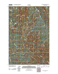
2011 Map of Wickiup Mountain
USGS Topo · Published 2011About this map
Wickiup Mountain and Wickiup Ridge dominate the center of this Clatsop County landscape, forming a high divide that separates several significant drainage systems. The topography is defined by the headwaters of the North Fork Klaskanine River, including its Middle Fork, which wind through the southwestern portion of the quadrangle. High-altitude water bodies such as Wickiup Lake and Middle Lake are tucked into the drainages of Bear Creek and Waterworks Creek, suggesting the area's importance for local water management and natural storage.
Find a feature on this map
30 named features on this map. Tap any name to fly to it.
Don’t see what you’re looking for? This feature index may not catch every label — zoom into the map to look around manually.
Map Details
Editions of this 2011 Wickiup Mountain Map
This is the sole edition of this map. No revisions or reprints were ever made.
Other maps of this area

1939 · Saddle Mountain
USGS Topo · 1:62,500

1940 · Svensen
USGS Topo · 1:62,500

1941 · Keasey
USGS Topo · 1:62,500

1941 · Cathlamet
USGS Topo · 1:62,500

1943 · Keasey
USGS Topo · 1:62,500

1943 · Saddle Mtn.
USGS Topo · 1:62,500

1948 · Vancouver
USGS Topo · 1:250,000

1949 · Cathlamet Bay
USGS Topo · 1:24,000

1949 · Green Mountain
USGS Topo · 1:24,000

1950 · Vancouver
USGS Topo · 1:250,000