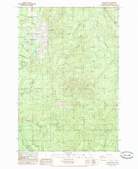
1985 Map of Wickiup Mtn
USGS Topo · Published 1985About this map
The City of Astoria Watershed dominates the northwestern corner of this mid-1980s terrain, where the John Day River and several tributaries rise from the slopes of Wickiup Mtn. This protected zone, marked by its strict Watershed Boundary, preserves the high-elevation drainage of Middle Lake and Wickiup Lake for municipal use. The surrounding landscape within the Clatsop State Forest is defined by a dense network of watercourses, including the North Fork Klaskanine River and the South Fork Klaskanine River, which carve through the timberlands. While much of the area is accessed only by 4wd tracks and forest roads, the presence of numerous quarries and a Borrow Pit points to the active resource management and road maintenance required in this part of Clatsop County. Landmark elevations like Elk Mountain and Knob Point provide orientation for those navigating the steep ridges between the Coon Creek and Walker Creek drainages.
Find a feature on this map
30 named features on this map. Tap any name to fly to it.
Don’t see what you’re looking for? This feature index may not catch every label — zoom into the map to look around manually.
Map Details
Editions of this 1985 Wickiup Mtn Map
This is the sole edition of this map. No revisions or reprints were ever made.
Other maps of this area

1939 · Saddle Mountain
USGS Topo · 1:62,500

1940 · Svensen
USGS Topo · 1:62,500

1941 · Keasey
USGS Topo · 1:62,500

1941 · Cathlamet
USGS Topo · 1:62,500

1943 · Keasey
USGS Topo · 1:62,500

1943 · Saddle Mtn.
USGS Topo · 1:62,500

1948 · Vancouver
USGS Topo · 1:250,000

1949 · Cathlamet Bay
USGS Topo · 1:24,000

1949 · Green Mountain
USGS Topo · 1:24,000

1950 · Vancouver
USGS Topo · 1:250,000