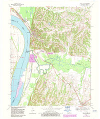
1970 Map of Wickliffe
USGS Topo · Published 1983About this map
The confluence of the Mississippi River and major rail lines anchors this 1970s view of Western Kentucky, where the Illinois Central Gulf Railroad crosses the river near Wickliffe. The landscape is a complex of wetlands and alluvial bottoms, featuring the Peal Land Wildlife Management Area and numerous backwaters like Lost Pond and Cane Slough. Historical markers of the region's long human habitation are evident at the Ancient Burial City and the Site of Fort Jefferson south of the town center. Local family history is preserved at the Harrison-Hughes Cem and Wickliffe Cem, while the industrial footprint of the era is seen in the Industrial Waste Ponds and a Gravel Pit. The map captures the intricate boundary between Ballard Co and Carlisle Co amidst the meandering course of Mayfield Creek.
Find a feature on this map
44 named features on this map. Tap any name to fly to it.
Don’t see what you’re looking for? This feature index may not catch every label — zoom into the map to look around manually.
Map Details
Editions of this 1970 Wickliffe Map
2 editions found
Other maps of this area

1928 · La Center
USGS Topo · 1:62,500

1931 · Cairo
USGS Topo · 1:62,500

1932 · La Center
USGS Topo · 1:62,500

1933 · Cairo
USGS Topo · 1:62,500

1939 · Wickliffe
USGS Topo · 1:62,500

1939 · Cairo
USGS Topo · 1:62,500

1949 · Paducah
USGS Topo · 1:250,000

1950 · Paducah
USGS Topo · 1:250,000

1951 · Blandville
USGS Topo · 1:24,000

1951 · Wickliffe SW
USGS Topo · 1:24,000