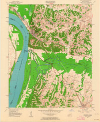
1951 Map of Wickliffe
USGS Topo · Published 1964About this map
The Mississippi River dominates this mid-century landscape where Kentucky meets Missouri at the confluence of the Ohio. The riverside town of Wickliffe serves as a focal point, positioned near the historic Site of Fort Jefferson. The map reveals a complex riverine environment of sloughs and chutes, including Island No 1 and Cane Island, which are separated from the mainland by the Island No 1 Chute and Back Slough.
Find a feature on this map
35 named features on this map. Tap any name to fly to it.
Don’t see what you’re looking for? This feature index may not catch every label — zoom into the map to look around manually.
Map Details
Editions of this 1951 Wickliffe Map
2 editions found

Other maps of this area

1928 · La Center
USGS Topo · 1:62,500

1931 · Cairo
USGS Topo · 1:62,500

1932 · La Center
USGS Topo · 1:62,500

1933 · Cairo
USGS Topo · 1:62,500

1939 · Wickliffe
USGS Topo · 1:62,500

1939 · Cairo
USGS Topo · 1:62,500

1949 · Paducah
USGS Topo · 1:250,000

1950 · Paducah
USGS Topo · 1:250,000

1951 · Blandville
USGS Topo · 1:24,000

1951 · Wickliffe SW
USGS Topo · 1:24,000