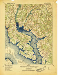
1920 Map of Wicomico
USGS Topo · Published 1920About this map
Wicomico River and its expansive tributaries dominate this coastal landscape at the southern tip of the Western Shore. The map illustrates a complex network of maritime and rail infrastructure, from the Ludlow Ferry crossing to the deep-water access points at Wilkerson Wharf and Blakistone Bushwood Wharf. Moving inland, the Pennsylvania R. R. serves established settlements like Bel Alton Cox Sta, while the Washington Brandywine and Point Lookout R. R. cuts through the northern interior near Charlotte Hall. The geography is defined by its watery margins, including the dense Zekiah Swamp and the wide Chaptico Bay. These features underscore a regional economy transitioning between traditional river transport and the growing reach of the railroad. For those tracing Maryland genealogy, the sheet captures numerous small landing-site communities and inland crossroads such as Newport, Chaptico, and Milestown before modern development altered the rural character.
Find a feature on this map
63 named features on this map. Tap any name to fly to it.
Don’t see what you’re looking for? This feature index may not catch every label — zoom into the map to look around manually.
Map Details
Editions of this 1920 Wicomico Map
This is the sole edition of this map. No revisions or reprints were ever made.
Other maps of this area

1889 · Fredericksburg
USGS Topo · 1:125,000

1890 · Mt. Vernon
USGS Topo · 1:125,000

1891 · Mt. Vernon
USGS Topo · 1:125,000

1892 · Leonardtown
USGS Topo · 1:62,500

1892 · Fredericksburg
USGS Topo · 1:125,000

1892 · Prince Frederick
USGS Topo · 1:62,500

1892 · Brandywine
USGS Topo · 1:62,500

1892 · Piney Point
USGS Topo · 1:62,500

1892 · Montross
USGS Topo · 1:62,500

1894 · Wicomico
USGS Topo · 1:62,500