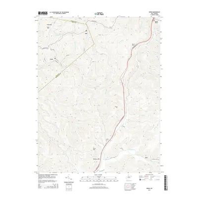
2014 Map of Widen
USGS Topo · Published 2014About this map
The boundary between Nicholas and Clay Counties cuts diagonally across this Appalachian landscape, where steep ridgelines and deep stream hollows define the pattern of settlement. In the northwest, the coal mining town of Widen sits along the Buffalo Creek drainage, connected to the nearby hamlets of Wattsville and Dille by a network of winding mountain roads like Dundon Widen Rd and Birch River Rd. The rugged geography is anchored by prominent elevations such as Powell Mountain and Corren Knob, with the eastern edge of the map bisected by the Mountaineer Expressway. Scattered family and community landmarks, including Spruce Run Cemetery and Hill Cemetery, are tucked into the valleys of Strange Creek and Muddlety Valley Road, reflecting a long history of rural isolation and small-scale timber and coal communities in central West Virginia.
Find a feature on this map
67 named features on this map. Tap any name to fly to it.
Don’t see what you’re looking for? This feature index may not catch every label — zoom into the map to look around manually.
Map Details
Editions of this 2014 Widen Map
This is the sole edition of this map. No revisions or reprints were ever made.
Other maps of this area

1889 · Nicholas
USGS Topo · 1:125,000

1891 · Nicholas
USGS Topo · 1:125,000

1893 · Sutton
USGS Topo · 1:125,000

1901 · Nicholas
USGS Topo · 1:125,000

1908 · Gassaway
USGS Topo · 1:48,000

1908 · Sutton
USGS Topo · 1:48,000

1910 · Sutton Special
USGS Topo · 1:62,500

1910 · Gassaway
USGS Topo · 1:62,500

1913 · Summersville
USGS Topo · 1:48,000

1915 · Cowen
USGS Topo · 1:48,000