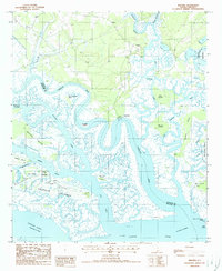
1988 Map of Wiggins
USGS Topo · Published 1988About this map
Wiggins sits at the northern edge of this intricate coastal landscape, where the Combahee River and Chehaw River systems converge in a complex network of tidal channels and low-lying land. In the late 1980s, this area remained dominated by expansive marshlands and protected grounds, including the Bear Island State G M A. The map captures the meeting of the Colleton and Beaufort county lines amidst a scatter of islands such as the Chisolm Islands, Williman Islands, and Gunboat Island. Navigation is a central theme of the geography, with the Intracoastal Waterway and the Ashepoo-Coosaw Cutoff cutting through the natural bends of the Coosaw River. Small landings and settlements like Chisholm and Ainslee provide evidence of human activity tucked between the larger water bodies like the Old Chehaw River and Social Hall Cr.
Find a feature on this map
37 named features on this map. Tap any name to fly to it.
Don’t see what you’re looking for? This feature index may not catch every label — zoom into the map to look around manually.
Map Details
Editions of this 1988 Wiggins Map
This is the sole edition of this map. No revisions or reprints were ever made.
Other maps of this area

1918 · Green Pond
USGS Topo · 1:62,500

1919 · Edisto Island
USGS Topo · 1:62,500

1920 · St. Helena Sound
USGS Topo · 1:62,500

1943 · Edisto Island
USGS Topo · 1:62,500

1943 · Green Pond
USGS Topo · 1:62,500

1944 · Fort Fremont
USGS Topo · 1:62,500

1947 · Savannah
USGS Topo · 1:250,000

1948 · St. Helena Sound
USGS Topo · 1:62,500

1948 · Savannah
USGS Topo · 1:250,000

1956 · Frogmore
USGS Topo · 1:24,000