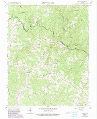
1966 Map of Wightman
USGS Topo · Published 1990About this map
The South Meherrin River and North Meherrin River converge at the boundary of Lunenburg Co and Mecklenburg Co, defining a landscape of rolling agricultural land and dense riverine systems. In this mid-century rural corridor, the community of Wightman serves as a central point along the roads connecting numerous family-named landmarks like Cox Corner and Pettys Corner. The importance of local congregational life is evident in the dense concentration of country churches, including Mt Horeb Ch and Union Ch, often located at strategic crossroads near small cemeteries.
Find a feature on this map
33 named features on this map. Tap any name to fly to it.
Don’t see what you’re looking for? This feature index may not catch every label — zoom into the map to look around manually.
Map Details
Editions of this 1966 Wightman Map
2 editions found
Other maps of this area

1953 · Greensboro
USGS Topo · 1:250,000

1954 · Greensboro
USGS Topo · 1:250,000

1955 · Chase City
USGS Topo · 1:62,500

1955 · Kenbridge
USGS Topo · 1:62,500

1955 · Boydton
USGS Topo · 1:62,500

1962 · Greensboro
USGS Topo · 1:250,000

1966 · Greensboro
USGS Topo · 1:250,000
1966 · Wightman
USGS Topo · 1:24,000
1966 · North View
USGS Topo · 1:24,000
1966 · Lunenburg
USGS Topo · 1:24,000