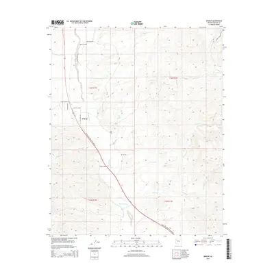
2014 Map of Wikieup
USGS Topo · Published 2014About this map
The settlement of Wikieup serves as a small hub in this arid landscape where the Mojave Desert transitions into the rugged drainage basins of the Big Sandy River. The map reveals a community defined by its water sources and desert infrastructure, including the isolated Cofer Hot Spring and the Noli Cem located south of the main townsite. The local geography is etched by a complex network of ephemeral waterways such as Natural Corrals Wash, Bitter Cr, and Sycamore Cr, which illustrate the seasonal hydrology of Mohave County. A modern residential grid is visible near the town center with roads like Country Club Dr and Golf Course Ave, contrasting with the surrounding open terrain and rural access points like Chicken Springs Rd and Pump Station Rd.
Find a feature on this map
22 named features on this map. Tap any name to fly to it.
Don’t see what you’re looking for? This feature index may not catch every label — zoom into the map to look around manually.
Map Details
Editions of this 2014 Wikieup Map
This is the sole edition of this map. No revisions or reprints were ever made.
Other maps of this area

1923 · Signal
USGS Topo · 1:250,000

1942 · Signal
USGS Topo · 1:250,000

1950 · Prescott
USGS Topo · 1:250,000

1954 · Prescott
USGS Topo · 1:250,000

1958 · Prescott
USGS Topo · 1:250,000

1959 · Prescott
USGS Topo · 1:250,000

1960 · Prescott
USGS Topo · 1:250,000

1965 · Prescott
USGS Topo · 1:250,000
1967 · Groom Spring
USGS Topo · 1:24,000
1967 · Gunsight Canyon
USGS Topo · 1:24,000