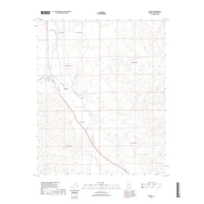
2018 Map of Wikieup
USGS Topo · Published 2018About this map
Wikieup serves as the central hub of this desert landscape, situated along the path of CO Hwy 159 and the Big Sandy River. The map illustrates a community shaped by its arid environment, where residential streets like Saguaro Sam Dr and Cholla Chuck Dr meet the expansive Mojave Desert. Local history is anchored by the Sandy Cem and Noli Cem, providing specific points of interest for genealogists tracking early families in this part of Mohave County. The terrain is defined by a complex system of drainage, including Natural Corrals Wash, Bronco Wash, and Gray Wash, which carve through the high ground of Boner Canyon. This survey captures the rural infrastructure of the late 2010s, from the Pump Station Rd utility routes to the local recreational layout of Golf Course Ave.
Find a feature on this map
29 named features on this map. Tap any name to fly to it.
Don’t see what you’re looking for? This feature index may not catch every label — zoom into the map to look around manually.
Map Details
Editions of this 2018 Wikieup Map
This is the sole edition of this map. No revisions or reprints were ever made.
Other maps of this area

1923 · Signal
USGS Topo · 1:250,000

1942 · Signal
USGS Topo · 1:250,000

1950 · Prescott
USGS Topo · 1:250,000

1954 · Prescott
USGS Topo · 1:250,000

1958 · Prescott
USGS Topo · 1:250,000

1959 · Prescott
USGS Topo · 1:250,000

1960 · Prescott
USGS Topo · 1:250,000

1965 · Prescott
USGS Topo · 1:250,000
1967 · Groom Spring
USGS Topo · 1:24,000
1967 · Gunsight Canyon
USGS Topo · 1:24,000