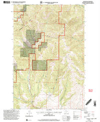
2001 Map of Wilborn
USGS Topo · Published 2004About this map
The high mountain topography of Helena National Forest dominates this landscape, where the Continental Divide winds through the high ridges of the Lincoln Ranger District. The terrain is defined by its deep drainage networks, with the waters of Canyon Creek and Specimen Creek carving through the slopes. At the heart of the transit through these mountains lies Flesher Pass, providing a critical crossing point for travelers moving through the divide.
Find a feature on this map
21 named features on this map. Tap any name to fly to it.
Don’t see what you’re looking for? This feature index may not catch every label — zoom into the map to look around manually.
Map Details
Editions of this 2001 Wilborn Map
This is the sole edition of this map. No revisions or reprints were ever made.
Other maps of this area

1889 · Helena
USGS Topo · 1:250,000

1893 · Helena
USGS Topo · 1:250,000

1899 · Helena
USGS Topo · 1:250,000

1903 · Helena
USGS Topo · 1:250,000

1943 · Hogan
USGS Topo · 1:125,000

1947 · Butte
USGS Topo · 1:250,000

1955 · Choteau
USGS Topo · 1:250,000

1957 · Choteau
USGS Topo · 1:250,000

1958 · Butte
USGS Topo · 1:250,000

1958 · Choteau
USGS Topo · 1:250,000