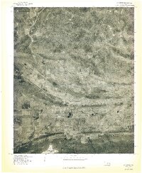
1977 Map of Wilburton
USGS Topo · Published 1977About this map
Wilburton sits as a central hub within the valley between the rising peaks of the Sans Bois Mountains to the north and the sprawling agricultural lands to the south. This 1977 orthophotomap, produced from aerial photography, provides a distinct visual record of the town's spatial layout and industrial footprints during the late seventies. The landscape is punctuated by water resources such as Lake Wayne Wallace in the northwest corner and Lloyd Church Lake at the southern edge, illustrating the critical management of water in this Oklahoma terrain. The visual data highlights the sharp contrast between the densely wooded mountain slopes and the developed corridors of the town, offering researchers a clear view of land use and transportation routes at a time when the region's coal and cattle economies were well-established.
Find a feature on this map
4 named features on this map. Tap any name to fly to it.
Don’t see what you’re looking for? This feature index may not catch every label — zoom into the map to look around manually.
Map Details
Editions of this 1977 Wilburton Map
This is the sole edition of this map. No revisions or reprints were ever made.
Other maps of this area

1900 · Sansbois
USGS Topo · 1:125,000

1901 · Tuskahoma
USGS Topo · 1:125,000

1908 · Tuskahoma
USGS Topo · 1:125,000

1909 · Tuskahoma
USGS Topo · 1:125,000

1909 · Sans Bois
USGS Topo · 1:125,000

1911 · Sansbois
USGS Topo · 1:125,000

1940 · Red Oak
USGS Topo · 1:62,500

1943 · Red Oak
USGS Topo · 1:62,500

1946 · Fort Smith
USGS Topo · 1:250,000

1950 · Mcalester
USGS Topo · 1:250,000