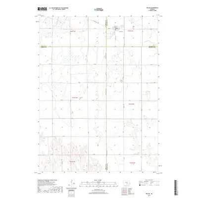
2017 Map of Wilcox
USGS Topo · Published 2017About this map
The town of Wilcox serves as the primary hub in this Nebraska agricultural landscape, situated where the borders of Kearney and Phelps counties meet. This 2017 survey captures the intersection of multiple rural jurisdictions, showing the convergence of Kearney, Phelps, Harlan, and Franklin counties. Local family history and genealogical research are well-supported by the presence of several established burial grounds, including Wilcox Cem just east of the village, Saint Johns Cem to the south, and the more secluded Freewater Cem located in the western portion of the quadrangle. The terrain is defined by a network of drainage systems such as Sacramento Cr, Center Cr, and the W Br Thompson Cr, which cut through the systematically gridded road network. The map reveals the rigid organization of the Great Plains township system, with clearly marked sections from t5n r17w down to t3n r16w, providing a precise spatial framework for land ownership studies.
Find a feature on this map
37 named features on this map. Tap any name to fly to it.
Don’t see what you’re looking for? This feature index may not catch every label — zoom into the map to look around manually.
Map Details
Editions of this 2017 Wilcox Map
This is the sole edition of this map. No revisions or reprints were ever made.
Other maps of this area

1896 · Holdrege
USGS Topo · 1:125,000

1955 · Grand Island
USGS Topo · 1:250,000

1957 · Grand Island
USGS Topo · 1:250,000

1958 · Grand Island
USGS Topo · 1:250,000

1970 · Holdrege East
USGS Topo · 1:24,000

1970 · Axtell West
USGS Topo · 1:24,000
1970 · Axtell East
USGS Topo · 1:24,000

1970 · Wilcox
USGS Topo · 1:24,000

1970 · Ragan
USGS Topo · 1:24,000
1970 · Hildreth
USGS Topo · 1:24,000