
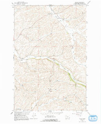
1964 Map of Wilcox
USGS Topo · Published 1965About this map
Union Flat Creek snakes through the center of this Whitman County landscape, defining the local geography alongside several other deeply incised drainages like Rebel Flat Creek and Alkali Flat Creek. The small settlement of Wilcox sits at a junction of these watercourses, while further north, the Union Pacific rail line cuts across the terrain near Mockonema. This 1960s survey illustrates a region shaped by both agriculture and transportation, evidenced by the Palouse Empire Fairgrounds and the County Memorial Airport near the northern boundary. For those tracing local heritage, the map identifies specific community landmarks such as the Onecho Ch and the adjacent Onecho Cem in the southern portion of the quadrangle. The presence of a Gaging Station on the creek and various labeled springs underscore the importance of water management in this rolling Palouse country.
Find a feature on this map
22 named features on this map. Tap any name to fly to it.
Don’t see what you’re looking for? This feature index may not catch every label — zoom into the map to look around manually.
Map Details
Editions of this 1964 Wilcox Map
2 editions found
Other maps of this area

1910 · Pullman
USGS Topo · 1:125,000

1950 · Penawawa
USGS Topo · 1:62,500

1950 · Endicott
USGS Topo · 1:62,500

1955 · Pullman
USGS Topo · 1:250,000

1958 · Pullman
USGS Topo · 1:250,000

1964 · Diamond
USGS Topo · 1:24,000

1964 · Colfax North
USGS Topo · 1:24,000

1964 · Colfax South
USGS Topo · 1:24,000

1964 · Ewartsville
USGS Topo · 1:24,000
1964 · Almota
USGS Topo · 1:24,000