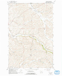
1964 Map of Wilcox
USGS Topo · Published 1991About this map
Onecho Ch and the neighboring Onecho Cem anchor the southern portion of this Whitman County landscape, reflecting the rural community life of the mid-20th century. The terrain is defined by a dense network of seasonal and permanent watercourses, including the prominent Union Flat Creek and Rebel Flat Creek, which carve distinct flats through the high country. In the northern reaches, the Palouse Empire Fairgrounds and the County Memorial Airport indicate a region serving as a local hub for commerce and recreation. Small settlements like Wilcox and Mockonema are situated along these drainages, where the economy was tied to the land, evidenced by Gravel Pits and various Springs that supported local agriculture and infrastructure before the widespread modernization of the late 20th century.
Find a feature on this map
19 named features on this map. Tap any name to fly to it.
Don’t see what you’re looking for? This feature index may not catch every label — zoom into the map to look around manually.
Map Details
Editions of this 1964 Wilcox Map
2 editions found
Other maps of this area

1910 · Pullman
USGS Topo · 1:125,000

1950 · Penawawa
USGS Topo · 1:62,500

1950 · Endicott
USGS Topo · 1:62,500

1955 · Pullman
USGS Topo · 1:250,000

1958 · Pullman
USGS Topo · 1:250,000

1964 · Diamond
USGS Topo · 1:24,000

1964 · Colfax North
USGS Topo · 1:24,000

1964 · Wilcox
USGS Topo · 1:24,000

1964 · Colfax South
USGS Topo · 1:24,000

1964 · Ewartsville
USGS Topo · 1:24,000