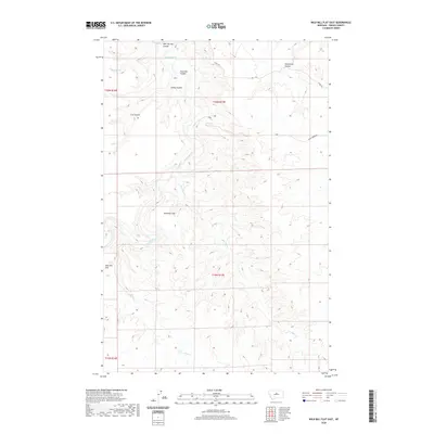
2020 Map of Wild Bill Flat East
USGS Topo · Published 2020About this map
The Judith River carves a winding path through Fergus County, creating a deeply dissected landscape defined by extensive coulees and high alluvial benches. This 2020 map highlights the stark topographical contrast between the river valley and the level expanses of Whitaker Flat and Wild Bill Flat. The drainage network is complex, with Box Elder Cr and Plum Cr feeding into the main channel, while numerous named drainages like Bear Springs Coulee and Threemile Coulee score the surrounding uplands. Local transit is limited to sparsely distributed routes such as 3 Mile Rd and the evocatively named Balky Horse Rd, reflecting the remote, agrarian character of the region. The map provides a precise record of the township and range divisions across this section of central Montana.
Find a feature on this map
16 named features on this map. Tap any name to fly to it.
Don’t see what you’re looking for? This feature index may not catch every label — zoom into the map to look around manually.
Map Details
Editions of this 2020 Wild Bill Flat East Map
This is the sole edition of this map. No revisions or reprints were ever made.
Other maps of this area

1954 · Lewistown
USGS Topo · 1:250,000

1959 · Lewistown
USGS Topo · 1:250,000

1964 · Wolf Creek Falls
USGS Topo · 1:24,000

1964 · Anderson Bridge
USGS Topo · 1:24,000

1978 · Wild Bill Flat West
USGS Topo · 1:24,000

1978 · Toney Bench
USGS Topo · 1:24,000

1978 · Seventytwo Hills
USGS Topo · 1:24,000

1978 · Wild Bill Flat East
USGS Topo · 1:24,000

1978 · Lewistown
USGS Topo · 1:100,000
1985 · Hilger NW
USGS Topo · 1:24,000